Through COSMO-SkyMed satellites by Agenzia Spaziale Italiana and Ministero della Difesa, e-GEOS carried out Radar acquisitions to analyse the area affected by the possible presence of spills from tankers. In the following image, processed via the e-GEOS SEonSE application platform for maritime domain monitoring, the positions and characteristics of the identified oil spills are highlighted.
Photo credit: Black Sea. COSMO-SkyMed Image © ASI. Processed and distributed by e-GEOS
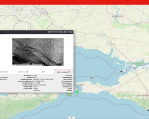
Image details:
COSMO-SkyMed ORDER ID = 3186470
e-GEOS ORDER NUMBER = 24F29157-15
AREA NAME = Feasibility_MN_CSK
Product Number 1
ACQUISITION MODE = STR_HIMAGE
ORBIT PASS = ASCENDING
LOOKING MODE = RIGHT
PROCESSING LEVEL = DGM_B
ACQUISITION START TIME = 2024-12-19 02:57:22.528192
ACQUISITION STOP TIME = 2024-12-19 02:57:29.233727
SATELLITE = SAR1
PRODUCT_FILE_NAME = CSKS1_DGM_B_HI_0A_VV_RA_FF_20241219025723_20241219025729.h5