

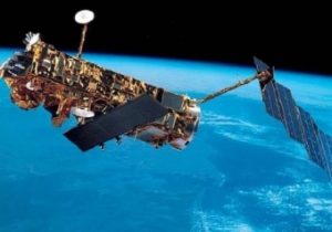
ENVISAT – (Environmental Satellite) was an ESA Earth Observation mission, and was active for 10 years. The satellite was the successor of the two ERS satellites, and was launched on March 1st, 2002, from the spaceport in Kourou, French Guyana, aboard an Ariane 5 carrier. It remained active until April 8th, 2012, the day when the communication with the ground-based stations stopped; on May 9th, 2012, after several attempts to re-establish contact and identify the reasons behind the lack of reaction by the satellite, the ESA declared the end of the mission.
ENVISAT was placed in a sun-synchronous polar orbit, at a distance of nearly 790 km from Earth, and had been designed to study and monitor the environment of the Earth at various levels: local, regional and global. Specifically, the goals of the satellite were: monitoring of the resources of the Earth (both renewable and non-renewable), study of the structure and dynamics of the Earth’s crust and the internal part of the planet and support to already active weather services. The fields where the data captured by the satellite provided a significant contribution are: climatology, meteorology, atmospheric chemistry, hydrology, protection of the environment, of the soil and the plant cover.
ENVISAT had a suite of 9 on-board instruments; some of them were advanced versions of those that came with ERS-1 and ERS-2, such as the AATSR advanced radiometer (Advanced Along Track Scanning Radiometer) and the Advanced Synthetic Aperture Radar (ASAR).
Same as it happened with ERS-1 and ERS-2, the ASI was also involved in this mission for the processing of the data acquired by ENVISAT by the I-PAF and I-PAC facilities, located by the Geodesy Centre of the Italian Space Agency in Matera.


