The NASA - ASI receiver was powered on March 3

04 March 2025


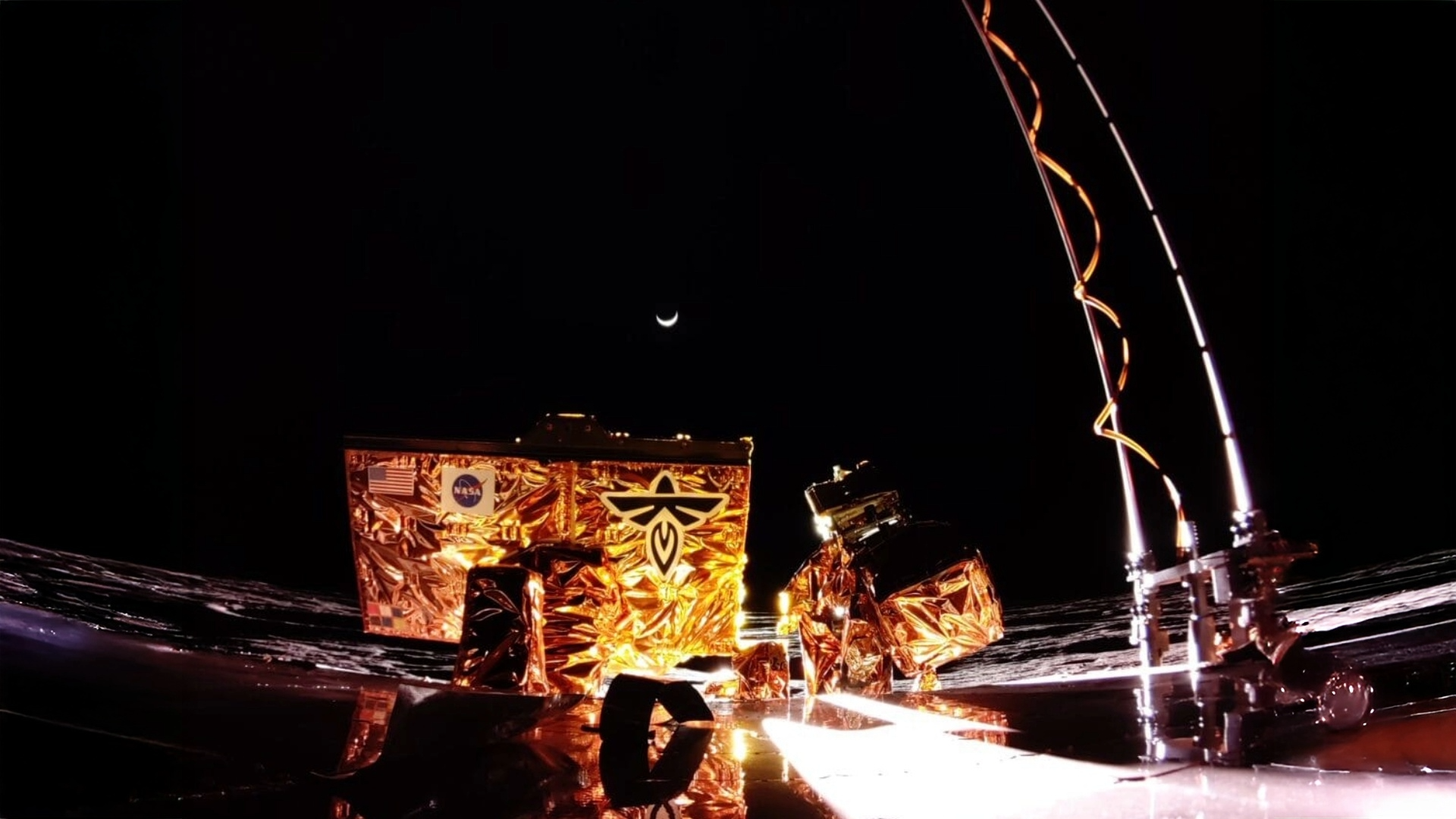
LuGRE has achieved for the first time in history the radionavigation positioning from the Moon, successfully capturing signals from Earth-based GNSS navigation systems. Nearly 24 hours after the Firefly Aerospace's Blue Ghost lander touchdown, the Italian receiver was powered on at 7:10 AM Italian time, marking the beginning of its lunar sky observations over Mare Crisium. LuGRE (Lunar GNSS Receiver Experiment) is a collaborative mission between the Italian Space Agency and NASA, developed in Italy by Qascom with scientific support from the Polytechnic University of Turin.


«LuGRE is a challenge we have won, and it does not surprise me nor, I believe, does it surprise us - said Teodoro Valente, president of the Italian Space Agency -  after the mission is completed, it will allow us to study the vast amount of data collected over two months, providing the scientific community with valuable insights for future developments and technological research. My thanks go to the entire Qascom team, the Polytechnic University of Turin, and especially the Nasa, Firefy Aerospace and ASI team, of whom we are proud for their tireless work in achieving these extraordinary milestones».


Prior to activating LuGRE, the lander underwent a series of system checks to ensure that its onboard systems and scientific instruments were fully operational. A vital step involved calibrating the gimbal, which precisely orients the antennas toward Earth. Only after confirming this alignment could LuGRE be activated to search for GNSS signals. The first GPS G25 signal on L1 and L5 frequencies was received at 7:48 AM, a moment of excitement for the control team, confirming that the receiver had come through landing unscathed and was functioning well. The orientation was confirmed as correct, and operations were as expected.


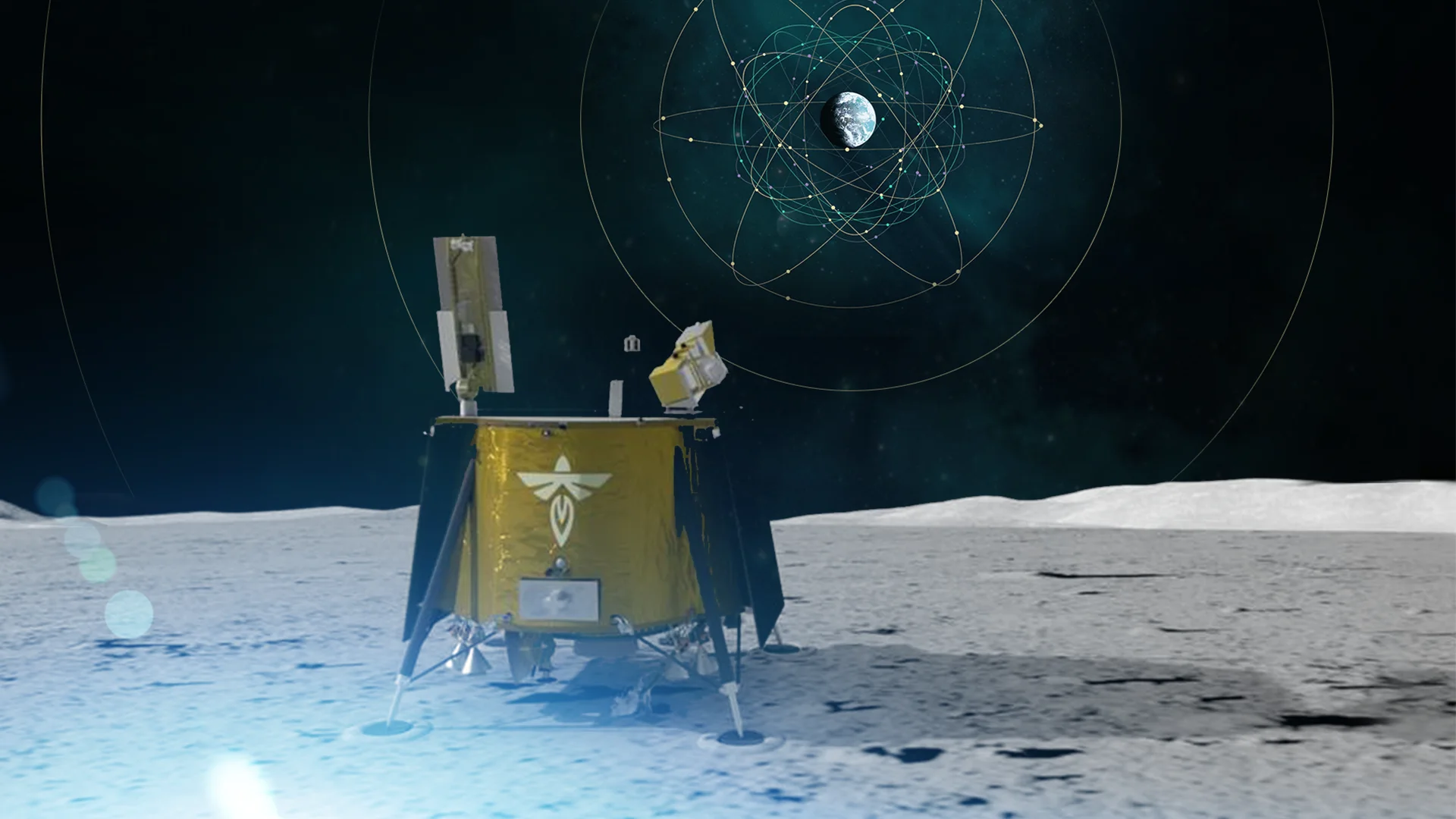
The real breakthrough came shortly after: upon analyzing the initial received data, it was shown that LuGRE locked and traced onto four satellites—two from GPS (G18, G25) and two from the Galileo system (E2, E34). This achievement enabled the first calculation of Position, Velocity, and Time (PVT) fixes on the lunar surface, utilizing signals from both the American GPS and the European Galileo systems. This milestone adds to a string of achievements for LuGRE. It is the first GNSS receiver to operate beyond Low Earth Orbit and is designed to work in both lunar orbit and on the Moon's surface. It is also the first active Italian instrument on the Moon, having received GPS signals from over 200,000 kilometres away and detecting Galileo signals beyond Earth’s atmosphere.


Moreover, LuGRE is pioneering in demonstrating the simultaneous use of GPS and Galileo signals in the lunar environment, a feat never accomplished before at such distances from Earth, with the farthest signal acquired being around 410,000 kilometres away. After landing, FireFly has performed all procedures required to confirm the nominal status of the lander and the readiness to start the science activities with all the 10 payloads. After this perfectly achieved complex milestone, FireFly has given the green light to NASA and ASI to re-activate LuGRE payload to operate on lunar surface over the next 14 days, until lunar night sets in, in continuous gathering essential data for future advancements in space navigation. The only planned downtime will be at lunar noon, when the lander will need to regulate its thermal systems without drawing energy from its scientific payloads. LuGRE will relay scientific data that will be instrumental in developing future lunar and cis-lunar navigation systems. The outcomes of this mission will pave the way for greater exploration possibilities and establish a more autonomous and dependable positioning system to support upcoming human and robotic missions on the Moon and beyond.

‣ News

MONDAY 17 MARCH 2025

LuGRE: mission successfully completed ‣

The mission of the receiver has concluded, marking a significant achievement following the completion of the Blue Ghost lander’s mission MORE...

FRIDAY 21 FEBRUARY 2025

LuGRE sets another record: first GNSS signals detected in lunar orbit ‣

This recent operation demonstrated that the receiver could use GNSS signals even near the Moon
MORE...

MONDAY 19 APRIL 2021

ENTRUSTED survey is under way ‣

ENTRUSTED is a European research project coordinated by the European GNSS Agency MORE...

THURSDAY 23 JULY 2020

Galileo Masters 2019, interview with the first Italian winners ‣

The Galileo Masters are the leading Innovation Competition for Satellite Navigation which annually awards prizes to the best services, products, and business concepts that use satellite navigation in everyday life. Since its initiation in 2004, the Galileo Masters mission is to spur on the development of market-driven applications based on satellite navigation technologies. The spectrum of submitted business solutions reflects the manifold opportunities made possible by this future‐oriented technology. Individuals and entire industries alike can benefit from satellite navigation in areas such as healthcare, leisure, traffic management, other rail, sea, and air transport logistics –to name just a few. The Italian Space Agency joined and supported the competition in 2019 for the first time. Here, we have the first Italian winners, Alex Minetto, Neil Gogoi, Giampaolo Marinaro and Maria Chiara Bello from the Polytechnic of Turin. They will tell us how this experience went and what the next steps are. How did you decide to get engaged with the Galileo Challenge 2019? The Galileo Challenge competition has a strong relevance in the GNSS landscape. Given the resources and effort dedicated by Europe in the creation of GALILEO, an independent satellite navigation system (albeit interoperable with currently existing systems), the competition is of significant interest for students and researchers operating in Europe (Italy for our case). Through our research, we have in our hands an innovative technology capable of improving nominal performance of the current GNSS receivers. By mutual agreement with our academic advisor Prof. Fabio Dovis and with the research team of which we are currently part of (NavSAS), we therefore decided to present our idea to the competition. Tell us something about you The CAPS.loc team consisted of two doctoral students, Alex, Neil and Giampaolo, who graduated in telecommunications engineering before the competition and a student, Maria Chiara, in the process of writing her thesis for graduation. We all came from different experiences but sharing the same passion for innovation, applied research and problem solving. Our careers have seen us engaged in the study of telecommunications engineering (Alex and Giampaolo albeit with a few years of difference and different study paths), ICT technologies focused on the innovative and sustainable development (Maria Chiara) and geodesy and applications related to the world of positioning (Neil). GNSS is an extremely multidisciplinary field truly open to the research and through our work and interests, we have merged towards applied research in navigation and positioning. Tell us, in summary, your idea We cannot disclose too much, let’s say … Today, many of the location-based services (LBS) related to urban mobility rely on smartphones. The availability of raw GNSS measurements on Android phones has opened the possibility of exchanging such measurements for improved accuracy, precision, robustness, and availability. Collaborative ranging and cooperative positioning (CP), if implemented with the smartphones’ ultra-low-cost GNSS chipsets, can enable a plethora of applications that support a modern smart city framework. Cooperative Android Positioning System for Localisation (CAPS.Loc) proposes developing an optimal framework on Android smartphones for the exchange and near-real-time exploitation of raw GNSS measurements, as well as improved LBS. It is expected to provide three key functionalities: A network structure for the real-time exchange of measurements, one white box for the combination of measurements by means of time synchronisation, and a second white box for the integration of collaborative data into the main navigation algorithm. Aside from being a server-based system, CAPS-Loc is expected to use direct connectivity among the users to ensure continuity of its service when mobile network is no longer available. What are the main technological challenges that you still have to face? The technological obstacles linked to this collaborative technology are due to the few implementation attempts made so far (or at least present in the literature). Although the effectiveness of this paradigm has been demonstrated at theoretical level in terms of improved accuracy and precision of the position solution, the difficulties of an effective simple implementation have hindered its dissemination making it probably unattractive or still too immature for immediate industrial/commercial applications. This is demonstrated by similar studies carried out in 2010 at MIT (U.S.A) and more recent research carried out in Europe by colleagues operating in other research centers and groups. The research carried out by Alex and Neil within the NavSAS group primarily aims to provide a solid theoretical framework on which to act flexibly according to the possible applications. What has been explored through the work of Giampaolo and Maria Chiara has subsequently brought the framework closer to mass-market devices, allowing us in fact to aim for field trials that could be considered a "worst-case" scenario at least in terms of hardware performance as the current work is limited precisely to ultra-low-cost GNSS receivers. Once the technology was tested and validated using such low-cost hardware, there would have been scientific confirmation of the feasibility of the idea even in non-ideal conditions. What are the most innovative technologies that can best support you in solving your challenges (eg artificial intelligence, etc.)? The application of the current new wave of artificial intelligence (machine learning and intelligent systems) are beyond the scope of our current work. The strong advertisement of such technologies indeed does not always correspond to actual intelligent and autonomous systems. At the moment we do not look at these algorithms as a need despite of the advanced statistical methods that are implemented in our solution. The algorithms studied so far to exploit cooperation are based on classic estimators well known in the engineering of automatic controls and extremely popular in the field of GNSS technologies. What our technology definitely needs is a network infrastructure that allows a rapid exchange of the few kB of data required for this service; that favors the exchange in the background using specific high priority and low latency protocols, as prefigured by the URLLC conceived for the 5G NR. Furthermore, the availability of low-cost integrated antennas and chipsets capable of supporting multi-frequency GNSS has paved the way for the improvement of cooperative solutions and protection measures against counterfeit signals. NavSAS is active and has acquired some experience in the latter area. Tell us something about your next steps. How do you plan to implement your project idea? Firstly, we want to present a brief history of developments following the Galileo Master challenge. With the research work carried out on raw measurements by Neil and Giampaolo and the application side work of Alex and Maria Chiara, it was possible to create a Proof-Of-Concept of technology based precisely on the receivers embedded in Android smartphones. The framework developed natively on the Android platform and based on a client-server system for the exchange of information was developed thanks to a funding from the European Space Agency as part of the HANSEL project, titled ‘A testbed for positioning in smart cities. It’s an App capable of interfacing with a back-end service installed on an AWS service which provides an improvement of the position totally free of charge without additional technologies or infrastructures. With this proof-of-concept completed, now is the time to extend the research on cooperative differential GNSS positioning and similar solutions in other areas, from vehicular networks to service robotics (rovers and drones) and why not, to extra-terrestrial navigation using GNSS signals for the positioning of spacecrafts in a cooperative way as well! What do you think about this experience? The experience of the Galileo Masters has allowed us to get in touch with young people from all over Europe engaged in the development of new ideas on the use of satellite navigation. We’ve met professionals from academia, from the industry and start-ups, all committed to supporting and fully exploiting the great scientific and technological effort of the GNSS systems. The comparison with different perspectives has allowed us to realize the potential of our idea and the stage of its development more effectively from a simple research concept to something palpable and functional in the field. Which were the aspects you liked the most and which less? The discussion tables set up with experts proved extremely interesting and highlighted the limits and potential of our idea. Unfortunately, coming from the academic and research world we found ourselves dealing with a limited entrepreneurial oversight from us (which is not part of our training and our personal interests) and for this reason we had to accept how distant our idea could be from a possible commercial product or launch base for a start-up. In this sense, it seemed to us that technological solutions from the context of pure and / or applied research require greater mediation in order to be comparable with ideas developed entirely in more industrial contexts where the business footprint is more evident. ASI began supporting this international initiative in 2019. How do you consider the support that has been provided to you by the Agency? After informing us of the outcome of the National competition, ASI participated in a presentation of the idea at the Politecnico di Torino and carefully followed the development of the idea, expressing their interest in the technological solution and possible fields of application. Following the candidacy and the award at the Space Oscar Night of the Galileo Masters, we talked on several occasions with the Agency on how our idea could be valued, and this interview is also one of the results of such fruitful collaboration. Some activities and project proposals promoted by NavSAS and other entities of the Politecnico di Torino are already in the pipeline with ASI, and clearly cooperative positioning could not be missing. Any advice or suggestions for those who want to participate in the Galileo or Copernicus Masters this year? The competition is based on the development of implementable technologies (not only experimental or research concepts) and on possible business solutions connected to them. Our advice for future candidates is to set up a working group that also considers knowledge related to the commercial sphere of the market. It is important however not to focus solely on economic factors, otherwise there is the risk of neglecting the technological and innovative impact, which in our opinion is the fundamental objective of this competition. What goals (personal or professional) do you have for the next year? Giampaolo: I currently work for an important Italian telecommunications company. I hope this professional experience gives me the opportunity to get to know today's communication technologies in-depth to discover tomorrow's. In fact, I consider it as one of my goals looking ahead. Maria Chiara: at the moment I work in the field of artificial vision, applied to industrial quality control and robotics. Innovation and experimentation are the passions that I continue to pursue even after the experience of the Galileo Master and the conclusion of my university cycle. Alex: I obtained my PhD in March 2020, and today I work as a Post-doc researcher at the NavSAS group in the Department of Electronics and Telecommunications of the Politecnico di Torino. Research and its dissemination are my main interests since the end of my master's degree course (together with a disproportionate number of passions and hobbies). Being able to continue on this academic path would be the ideal crowning of a doctorate that enriched me humanly and professionally. Neil: My main goal is to complete my doctorate within the next year. Following which, I plan to continue working on this framework by improving it and applying it in the area of my interest, i.e. navigation of service robotics. What would you tell an investor potentially interested in your innovation? The cooperative positioning concept developed and designed in this case for Android platforms, aims to respond to the need for superior performance in complex scenarios for GNSS systems (such as the urban environment). It does this by taking advantage of the capabilities of the cellular mobile network (and / or Wi-Fi networks) and current GNSS technology integrated in smartphones. CAPS.loc can be conceived as a service offered in the form of Road-Side Unit (RSU) devices that support the low-latency exchange of raw data or alternatively it can be integrated natively in the operating systems of mobile devices in order to limit the demand for additional infrastructure. We feel, to promote a widespread diffusion of multi-platform operating systems such as Android and to equip these systems with CAPS.loc technology in order to offer a distributed cooperative positioning, the verb "to share" needs to be redefined according to a worldwide improvement of our living conditions. The framework has considerable potential and combined with current low-cost technologies; it can guarantee improved performances by exploiting the multiplicity of terrestrial devices rather than that of satellites in orbit thus also promoting greater sustainability of GNSS systems for the future.