Less than a month after its launch, the COSMO-SkyMed Second Generation second satellite (CSG FM2) acquired the first images showing outstanding capabilities. The Program, funded by the Italian Space Agency (ASI) and the Ministry of Defense, with the contribution of the Ministry of University and Research, is currently in its Commissioning (i.e. in-orbit testing) phase. The images have been acquired over the Pine Island glacier, the South Pole, the plateau near Pordenone (Northern Italy), and some islands in the Galapagos archi-pelago.
The COSMO-SkyMed Second Generation system, has been realized to ensure an operational continuity to the first generation, introducing at the same time several leaps ahead in terms of technology and user services. The first satellite was launched in 2019, with four first-generation ones still operational and launched between 2007 and 2010.
The COSMO-SkyMed constellation can provide the user data of exceptional value in terms of applications they can be used for, including infrastructure monitoring, emergency management, climate change monitoring, and security. In addition, the Second Generation's new capabilities, including the "quad pol" and the improved resolution in several acquisition modes, opened the field to several new applications.
In this program, the Italian national industry plays a crucial role, with Leonardo and its joint ventures Thales Alenia Space and Telespazio, together with a significant number of small and medium-sized enterprises. In particular, Thales Alenia Space, a joint venture between Thales (67%) and Leonardo (33%), is the prime contractor responsible for the entire system, while Telespazio, a joint venture between Leonardo (67%) and Thales (33%), is responsible of the ground segment and hosts the command and control center of the constellation at the Fucino Space Center. Leonardo also contributes to the program by providing the star trackers for the orientation of the satellite, photovoltaic panels (PVA) and electronic units for the management of the electrical power. COSMO-SkyMed data is marketed worldwide by e-GEOS (Telespazio 80% and ASI 20%).
To download high resolution images and captions : https://we.tl/t-dsKY3wZka3
Photo credit: COSMO-SkyMed Product - ©ASI - Agenzia Spaziale Italiana - 2022. All rights reserved. Distributed by ASI and processed by e-GEOS
-
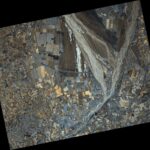
- The image shows the Magredi, the so-called “Pordenone steppe”, an area of the high Friulian plain at the center of a kind of “V” formed by two rivers, the Meduna and the Cellina. Here the streams meet and flow together towards the valley, to sink underground, into the aquifer, leaving exposed a thick alluvial blanket of limestone-dolomite-mythical conglomerates. In the south-west corner of the image, the city of Pordenone can be clearly recognized.Credit: COSMO-SkyMed Product – ©ASI – Agenzia Spaziale Italiana – 2022. All rights reserved. Distributed by ASI and processed by e-GEOS
-
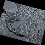
- Pine Island Glacier, Antarctic. The image shows large icebergs calving from the glacial platform. Credit: COSMO-SkyMed Product – ©ASI – Agenzia Spaziale Italiana – 2022. All rights reserved. Distributed by ASI and processed by e-GEOS
-
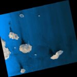
- The image shows some of the islands of the Galapagos archipelago (San Cristobal Island, Santa Cruz Island and Santiago Istand), in the Pacific Ocean. The picture shows the sea waves and their interactions with the islands around. Credit: COSMO-SkyMed Product – ©ASI – Agenzia Spaziale Italiana – 2022. All rights reserved. Distributed by ASI and processed by e-GEOS