

COPERNICUS, previously known as GMES (Global Monitoring for Environment and Security) is a complex Earth satellite observation programme, launched in 1998 by the European Commission and by a pool of space agencies. As a contribution by the “Old Continent”, it’s part of the broader GEOSS project, which aims at developing a System for Earth global observation systems. But its main purpose is to guarantee a substantial autonomy to Europe in regard to the detection and management of data on the health of our planet, by supporting the needs of European public policies through the supply of accurate and reliable services in terms of environmental and safety aspects.
Amongst the applications regarded as “Priority” within the programme are the management of natural disasters and the monitoring of oceans, vegetation and atmosphere. Furthermore, the development of the project provides that COPERNICUS will play a very important role also in other contexts: from those related to climate changes to civil protection and sustainable development, without forgetting the impact on the EU social and safety policies: in fact, the system will offer the possibility to manage accurate and updated data, for example, on the movements of refugees, on the needs for logistic support to military missions and on any terrorist threat.
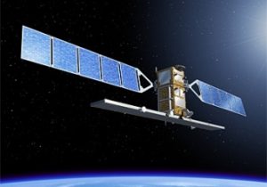
COPERNICUS is based on a set of six types of satellites, called Sentinels and specialized in specific applications: pairs 1, 2 and 3 have already been launched. The Sentinel-1 are used to produce interferometric radar data; the Sentinel-2 optical satellites have been designed for multispectral observation; the Sentinel-3 have been designed to conduct oceanographic and terrestrial observations; the geostationary-type Sentinel-4 will be used to monitor the atmospheric components; the low-orbit Sentinel-5 satellites will monitor the atmosphere’s chemical composition; finally, the Sentinel-6, whose launch is scheduled for 2020, will study the surfaces of the seas and oceans for climatological purposes.
In particular, the Sentinel-3 system, which is placed in a sun-synchronous, nearly polar orbit and will weigh about 1.200 kg, will be used for oceanographic observations and to monitor the vegetation, and is capable of observing the topography of the seas, the surface temperature of the waters and the landmass. It provides a key contribution to predict both sea conditions, which are essential for a save navigation, and the Earth’s climate.
Within the COPERNICUS Programme, the European Space Agency is in charge of the space segment of the programme. In February 2008, the European Commission allocated about 624 million euro for the development of COPERNICUS’ space segment, which are added to the more than 700 million euro that had already been allocated by the ESA member countries. During the ministerial meeting in November 2008, an additional 831 million euro were allocated for the development of COPERNICUS; 120 million euro were allocated by Italy.
The main European companies were tasked with the manufacturing of the Sentinels: the French-Italian company Thales Alenia Space manufactured Sentinel-1 and Sentinel-3, while the German Astrium was tasked with the manufacturing of Sentinel-2. The three pairs of satellites were launched between 2014 and 2018 and are now operative.


