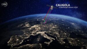
The Italian Space Agency intends to benefit from the knowledges and skills matured by the Italian Space Industry in the design and development of a space Raman lidar system for Earth observation, with the goal to launch a multi-purpose space LIDAR mission dedicated to the observation of the Earth’s atmosphere, surface and oceans and their mutual interactions, named CALIGOLA. CALIGOLA, which stands for Cloud Aerosol LIDAR for Global Scale Observations of the Ocean-Land Atmosphere System, aims at collecting an unprecedented observational dataset capable to generate increasing scientific knowledge in the areas of atmospheric, aquatic, terrestrial, cryospheric and hydrological sciences.
Space missions dedicated to science applications are of paramount importance for ASI as they allow to extend the Earth Observation capabilities made available to the scientific community, at international level, and consolidate the leadership of the Italian Space industry in the development of active remote sensors for Earth Observation.
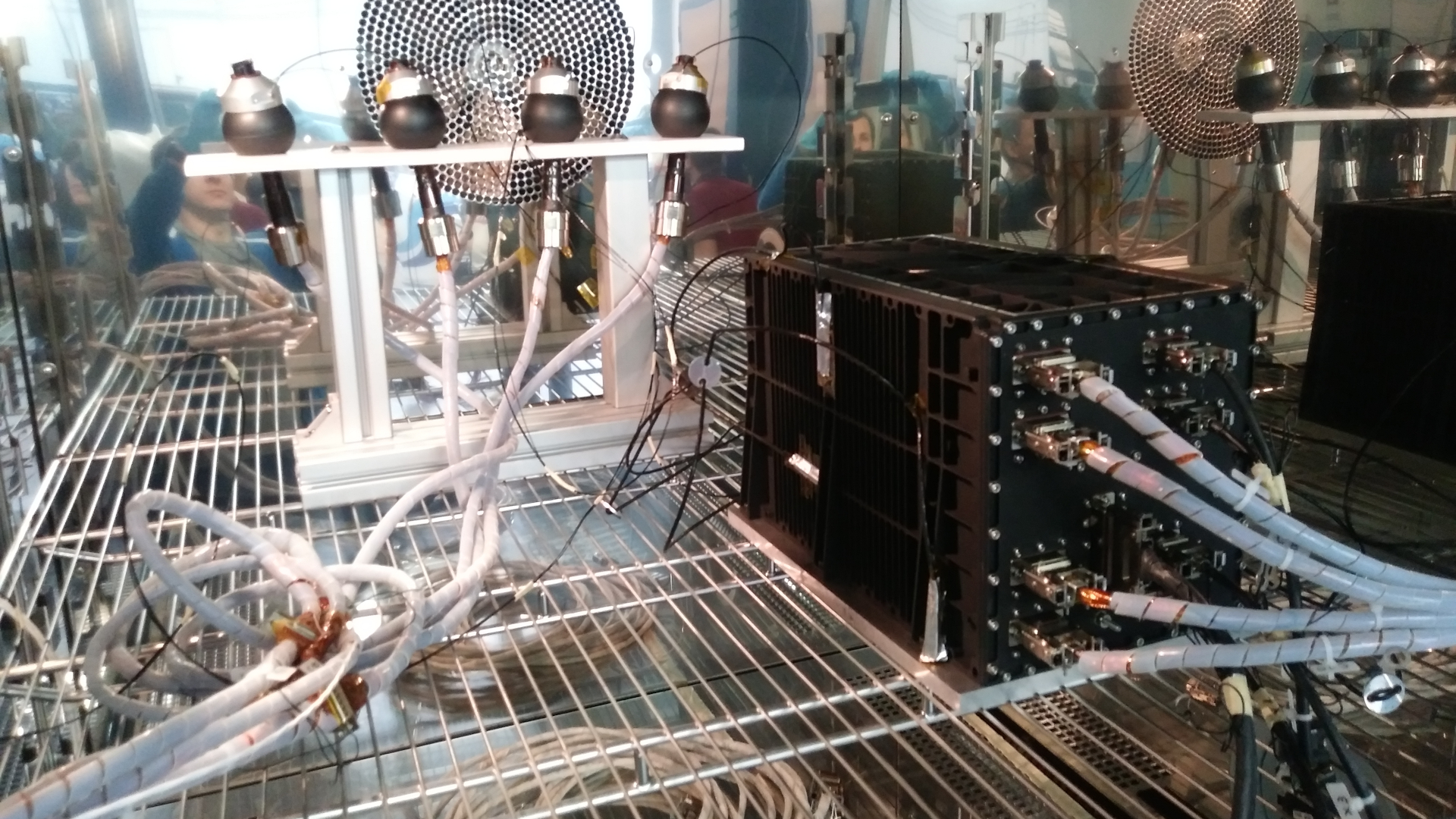
The intent is to develop a state-of-the-art three-wavelength Raman LIDAR, benefitting from the UV, visible and infrared pulses emitted by a powerful Nd:YAG laser source and from the exploitation of all possible atmospheric/surface/oceanic elastic and anelastic echoes stimulated with these three wavelengths.
More specifically, based on the measured elastic (Rayleigh-Mie), fluorescent and Raman LIDAR echoes from the atmospheric constituents stimulated at 354.7nm, 532nm and 1064nm, CALIGOLA will be able to perform profile measurements of:
- the particle backscatter coefficient from aerosols and clouds at 3λ
- the depolarization ratio at 3λ,
- the particle extinction coefficient at 355 nm,
- the particle fluorescent backscatter coefficient at 450-460 nm
Based on the measurements of co-located profiles for this ample ensemble of optical parameters, CALIGOLA will allow to determine the microphysical and dimensional properties of suspended particles (aerosol and clouds) and facilitate atmospheric particle typing.
Further mission objectives include the exploitation of elastic backscatter echoes from the sea surface and the underlying layers, and their degree of depolarization, this measurement capability allowing CALIGOLA to perform measurements of sea optical properties and suspended particulate. This information is fundamental to properly characterize phytoplankton seasonal and inter-annual dynamics and to improve our present understanding of the role of phytoplankton in marine biogeochemistry and in the global carbon cycle and improve the comprehension of the response of marine ecosystems to climate variability.
One specific measurement channel at 450-460 nm will be dedicated to the fluorescence measurements from atmospheric aerosols and marine chlorophyll, for the purpose of aerosol typing and for the characterization of ocean primary production.
CALIGOLA will also allow accurate measurements of the small-scale variability of the earth's surface elevation primarily associated with variations in the ice and snow level, terrain, vegetation and forest canopy.
In 2021 the Italian Space Agency has started scientific and technological activities for the design and develop CALIGOLA, with the goal to launch the mission in the time window 2030 - 2031.
A scientific study in support of the development of the instrument and the mission started in November 2021 and is on-going, commissioned by the Italian Space Agency to University of Basilicata, with Prof. Paolo Di Girolamo being responsible for these activities and having been appointed as Principal Investigator and Project Scientist of the CALIGOLA mission.
At Università della Basilicata, the Lidar Laboratory has matured a 35-year scientific research background in the design, the experimental development and the operation of ground-based, air-borne and satellite-borne lidar systems primarily used for the study of meteorological and climatic parameters. The research activity concentrates on the exploitation of LIDAR measurements for the study of the compositional, micro-physical, radiative and dynamical properties of the atmosphere, with particular emphasis on aerosol, water vapor and ozone research. The design and sizing of lidar systems, especially for space applications, implies the development of performance simulators, which represents another important aspect of the research activity carried out at the Laboratory.
A Phase A study of the LIDAR instrument feasibility started in October 2022 and is on-going, commissioned by the Italian Space Agency (ASI) to Leonardo S.p.A. (LDO). The activity is based on the important heritage and background of LDO in the development of LIDAR instruments (i.e. ALADIN on ESA Aeolus mission and ATLID Instrument on ESA EarthCare mission), with the present development substantially differing from those previous because of the increased number of emitted wavelengths and receiving channels of the present mission and the increased diversity of addressable scientific questions.
Furthermore, ASI started several technological developments in order to increase the TRL in LIDAR sector.
During the initial mission definition activities, the Agency encountered NASA's interest in the scientific objectives and specificity of the mission and, in this direction, a very effective interaction was started, since the beginning of the activities, with NASA.
At the end of October 2023, a face-to-face meeting was held in ASI HQ with an expert NASA team belonging to the Langley Research Center (LaRC), a NASA center of excellence in located in Hampton, Virginia.
ASI-NASA started a fruitful cooperation to finalize the mission objectives in terms of:
1) atmospheric/oceanic scientific goals,
2) atmospheric/oceanic parameters to be measured to achieve these scientific goals,
3) observational requirements (accuracy, precision, vertical and horizontal resolution, sounded vertical range) for atmospheric/oceanic parameters.
NASA enormous expertise in the design and development of space lidar systems for Earth Observation purposes has been demonstrated in a variety of past and present space lidar missions. NASA involvement in the CALIGOLA mission is primarily centered on the design and development of detectors and sampling systems covering the very large dynamic range of atmospheric-surface-ocean lidar echoes, which would represent a key element for the success of the mission.
NASA’s priority in the frame of the CALIGOLA mission is to address the Aerosol and Cloud, Convection and Precipitation (ACCP) Designated Observables identified by the 2017 Earth Science Decadal Survey. NASA is also coordinating Atmosphere Observing System Project (AOS) regarding mutually supportive science. NASA is also interested in contributing to the development of a “multifunctional” LIDAR (e.g., ocean profiling, snow depth, terrestrial vegetation, etc.), sharing ASI’s goal of pursuing a multi-disciplinary mission.
The use of LIDAR technology to obtain information on the characteristics of the atmosphere and the Earth's surface is a technique that has already been exploited in the past and will be considered in several future missions. Among others:
- the NASA Lidar In-space Technology Experiment (LITE) , which flew on the Discovery Space Shuttle in September 1994;
- the NASA-CNES Mission CALIPSO (Caliop), launched in 2006, just decommissioned;
- the NASA-CATS, operated from February 2015 to October 2017 onboard the International Space Station;
- ESA Mission AEOLUS (Aladin), launched in 2018, just decommissioned;
- ESA Mission EarthCARE (Atlid), to be launched Q1-Q2 2024, with expected lifetime of 3 years, hopefully extendable up to 5 years;
- DLR-CNES mission MERLIN (Methane Remote Sensing Lidar Mission), to be launched Q1 2028;
- NASA Mission “Aerosol-Cloud-Ecosystem” (ACE), now Atmosphere Observing System (AOS), AOS-I, launch in 2029, AOS-P launch in 2031-2032, both hosting backscatter lidars.
NASA Ref: https://www.nasa.gov/